Category: ru29 (Page 16 of 22)

Update for April 25

Hey All!

As we finish the final preparations for Antonio’s award ceremony and travel plans for this weekend, our Global Glider fleet continues to make progress flying the North and South Atlantic Basins.

To the North, Silbo is chugging along, slowly making his way towards the Caribbean:

Now just under 1500 km away, Silbo has his sights on the finish line and is continuing to battle through the currents towards the tropical shores of Barbados.

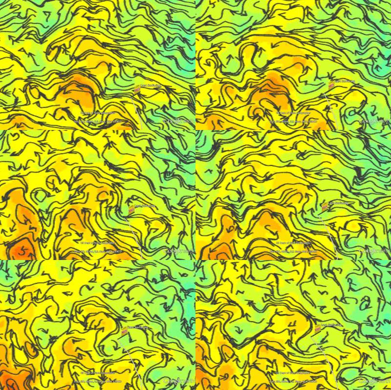
Looking to Pinzon’s visualization of the HyCOM currents (above and below), the waters at depth continue to be largely unfavorable as they flow to the Northeast, slowing our progress towards the Caribbean to our west. We can only hope that these negative currents do not persist much longer as Silbo has now been flying for over 270 days, 50 more than it took Scarlet to cross from NJ to Spain!

To the South, Challenger is continuing to be a beast as she is now cruising through the waters of the South Atlantic

Below, we can see that as the currents are continuing to swing further into our favor, our speed has dramatically increased, shown by the spike in the blue line.


With the depth average currents over the top 1000m of the water column now showing a northern component to the eastern flow that Challenger has been fighting, we have been able to take advantage of even that little extra push allowing speeds of over 25 km/day!  These speeds, if we can maintain them could get us to Brazil somewhere around December, leaving us with a good two months of wiggle room with our battery packs.


Force Wind Sea & Honor

Pushing Onwards

Hey All,

So towards the middle of last week after our progress continued to dwindle due to the poor currents flowing to the south east, Dave and I move the way point back to the north east, right on top of Ascension Island.  This location we were hoping would give 29 enough wiggle room to get going in the right direction without trying to overcompensate too much for the poor currents, effectively reducing our speeds.

Now after a few days, it looks like it is finally starting to pay off:

After the dip we suffered towards the end of last week, Challenger’s velocity is beginning to bring itself back up as the currents slowly spin around to the east from southeast.

Looking to Pinzon above, we are hoping that the new way point will allow us to swing around to the north and then north west the as oscillation of the currents becomes more favorable as time goes on.

Looking to the engineering data that Dave keeps us up to date on (seen in the figures above and below) we can see that as our speeds increase, Challenger is continuing to glide smoothly through the water. Above we can see the smooth profiles of our yo’s as we dive to 1000m and then climb back up to just over 100m from the surface as to avoid the productive waters at the surface.

Below we can see that with the way point back to the west, our heading error has dropped back to acceptable levels from the compass issues we were having earlier in the mission.

To the North, Silbo continues to push westward parallel to the equator as we set our eyes on our new caribbean goal.  Now just 1500 km from Barbados, we expect that Silbo could make it there as early as late July.  Once there he will receive a much deserved rest before getting new batteries and setting sale once more to continue his course along the North Atlantic Gyre.

Unfortunately, we are still seeing unfavorable currents at depth that want to push Silbo back to the north east direction.

We can also see that after everything Silbo has been through, he is showing signs of being tired.  He is flying much slower than 29 and the flight through the water is much less smooth.  The pump also continues to move multiple times on dives and climbs indicating there may be an issue that will need to be resolved after we recover

Force Wind Sea & Honor

10,000 km Later

Hey All,

So last night Silbo hit another mile stone in the Challenger Mission, completing his 10,000 kilometer at sea!

Since June 2011, this brave little droid has been through a lot, flying 3 segments totaling over 500 days at sea and over 10,000 kilometers, all while providing our team valuable data and experiences that in turn are helping us lay the frame work as we build for the inauguration of the full Challenger  Mission in the coming years.

Looking to the figure above, Antonio and his group at the University of Las Palmas has now made an operational version of the our 4-D Pinzon ocean model visualization platform for Silbo and HyCOM for the North Atlantic.  With this tool, we can now see how different a picture there is between models that show what is happening at the surface versus what occurs at depth. Looking to the depths, we can see how below the surface layer, the landscape is much different as the current is moving North- Northeast instead of Northwest as the surface models and drift suggest.

As we stand now, Silbo is roughly 1,600 km from Barbados where we have recently begun to make new contacts.  This leaves Barbados as a good potential end point for Silbo’s mission at which point will be breaching 1 year at sea.

To the South, Challenger is continuing to battle on as she fights towards the new way point to the north.

HyCOM visualized in Pinzon in the figures above and below is proving to be pretty accurate as the currents at depth match up quite well with the depth average currents being recorded by Challenger, both showing an overall flux to the east.  Looking ahead however, it looks like we are on the verge of encountering a large warm eddy to our north west which will at first swing the currents to the northeast, then to the north, and eventually favorable to the north east over the coming week.  This we hope will bring our speed back up well into the  higher 20 kms/ day as we have slowed a bit in this unfavorable current.

As this day comes to an end, Challenger is still 1200 km from St Helena, 2400 km from Ascension, and 4,800 km from Brazil.  Still a long ways away from the finish line, but continue to fly strong.

Force Wind Sea & Honor

Take a Step to the Left

Hey All,

So over the past few days, Challenger has continued to fly to the North, following the way point that we put into action before the weekend.

In the plot above, we can see that we were able to increase our speed a bit, however we reached our extent of how far we wanted to fly north.  Now that we have started flying back to the west, our velocity has began to drop a little once again.  This we don’t think will be a sustained drop as the currents seem more favorable in the near future.

The current seems to rotate to the north west not too far from our current location and so we hope we will begin to see more favorable currents begin to help us along our way.

To the north, Silbo has continued to see some interesting events as he crosses the Mid Atlantic Ridge that Antonio has created some great imagery for:

As Silbo continued to cross the ridges, we saw once again the oscillations in current that we hypothesized were similar to the interactions planes see while flying over mountains.

Thanks to the 3-d imagery of the sea floor from google earth, we are able to see the ridges and trenches our little droid has been traversing.  Some of these mountains actually resulted in nearly 4000m differences in a very short distance! The pressure caused by the water being forced through this area by the flow of the gyre may be what has caused the circulation of the current recorded by Silbo.

Force Wind Sea & Honor

Trying to the North

Hey All,

After struggling against this miniature eddy field over the past few days, Dave and I have decided to take the way point to the North to see if we can salvage some speed instead of flying straight through this unfavorable current.

Although at the surface we seem to have a favorable current, which is then confirmed by our location due to surface drift during data transfers, subsurface, we are still dealing with the eddies that have slowed us over the past two weeks. We hope now by taking Challenger to the North, we can try and head off these eddies and take a route a little over a hundred meters to the north that we hope to ride to the north west on our way to St. Helena.

To the north, Silbo continues to fly across the Mid Atlantic Ridge.  Here, we have discovered something ver peculiar:  there seems to be an inertial oscillation as we cross the peaks of the subsurface mountain range!

We will investigate further over the next couple days, but the change in current direction seen by Silbo seems to match up well with the ridges, possibly an occurrence similar to the updraft airflow over the tops of mountains seen in aeronautics.

On another note, I would just like to congratulate Dr. Antonio Ramos on receiving the RUCOOL Technical Achievement Award for Cyber Navigation! Our good friend Antonio and his team at the University Las Palmas Gran Canaria have been working hard creating the 4-D Visualization tool Pinzon that allows us to see the marine conditions around RU 29 in both space and time.

Antonio will be visiting Rutgers the first week in May to meet with the Ocean Observatories class and to accept his award.

Force Wind Sea & Honor!

Challenging the Models

Hey All,

As our gliders continue to push onwards, both has slowed down a little as we encounter some less than favorable currents.

From the start of this month through this week, Challenger has run into an eddy that developed as we approached leaving us little time to react, resulting in us flying our glider up the eastern side of a clockwise rotating eddy:

In the animation above, we can see how as the glider approached the area in question as there appeared to be currents that flowed up to the north west.  Then as we got closer to the area, the currents shifted and by the time we were about even with the center of the small eddy, the currents then accurately showed the rotation that was plaguing our progress.

Although this causes some frustation as the pilot when we lost some of our speed, instances such as this do leave us with a sense of accomplishment as we can see the data from our gliders being reflected in the models that our data is being plugged in to.

We can also see the fight with this eddy reflected in the velocity data above.  As we approached the eddy, we can see how our velocity continued to plummet until just recently as we rounded the edge of the eddy and now we seem to be increasing ever so slightly.  Hopefully we will be able to sustain this increase in the coming days and build up some more speed.

Over the next day, we will also be keeping an eye on the bathymetry around both Challenger and Silbo, asa they both are in the midst of obstacles:

Challenger is crossing the last of the sea mounts that are associated with the chain we have crossed a number of times now as we put distance between ourselves and the African Coast.

Silbo on the other hand is about to cross the Mid Atlantic Ridge for the second time, the firs being back in June of 2011 when we deployed out of Iceland along the Mid Atlantic Ridge.

Both of these regions reach up less than 1000m in some regions but we have taken the necessary precautions to make sure we do not run aground.

Force Wind Sea & Honor

Continuing the model comparison

Hey All

This semester, I have made the leap transitioning to being a lecturer for the Ocean Observatories course that I took every semester under Scott Josh and Oscar for 4 years beginning with the fall semester of RU 17.  And in helping with the class, I have built a model comparison tool that takes the data from both Challenger and Silbo and compares it to the data provided to us by the ocean models we have utilized as our road maps.  These models not only provide us with the direction of the currents, but also have temperature and salinity.


One observation we have made now that we are tracking the comparisons, is that it seems that the models are underestimating the temperatures at depth; not fully capturing the temperature transfer at depth in the vertical direction.  This could potentially skew the results of forecasts made based off of this data for such cases as climate change and other cases dependent on similar data.  To aid with this, the data from Silbo and Challenger is now being fed back into the models to hopefully aid in the accuracy as we provide data points that were not previously available.

A few days ago, Silbo suffered from another mysterious reset at depth, followed by an increase in movement by the pitch battery- with little trace of why this is occurring   After analyzing the data, the movement of the battery is still not completely known, however our friends up at TWR have been able to lock it down and reduce the movement.  This has allowed Silbo’s spike in energy usage to level off returning the estimate on how much energy remains into next year; well past our estimated date of arrival in the Caribbean in mid summer.

Challenger is continuing to fly well, however, we seem to have found a small eddy that is rotating against our favor, effectively slowing us down.  Over the next couple days, we will continue to explore this anomaly and make a decision as to where to go from here.

Force Wind Sea & Honor


Billy the Kid and Calamity Jane

Hey All

So almost simultaneously this weekend, our two gliders, Challenger and Silbo, have each crossed major milestones for our Very Important Glider Club: Challenger passed the 2000 km mark and Silbo the 4000!


As impressive as this is, Challenger’s numbers are even more so as she has gone half the distance that Silbo has done in a fraction of the time.

Both gliders are continuing to keep their speeds at respectable numbers as well.  Challenger, although we are seeing a decline in our velocity as we have found ourselves falling into what seems to be an unfavorable current, she is still above 20 km/day.

Silbo on the other hand, seems to be leveling out a bit just below 20 km/day.


Based on these numbers, if our two Global class gliders can maintain these speeds, we can expect Silbo to arrive in the Caribbean somewhere in the middle of July.

To the South, Challenger running 20+ km a day may carry us across to Brazil by the end of the year, leaving us with roughly 40 days of wiggle room on our battery power.

Force Wind Sea & Honor


To Fly the Gyres or to fly the X

Hey All,

So today in the Ocean Observatories course taught by Scott Glenn, Oscar Schofield and Josh Kohut, I proposed a question to the 70+ students in attendance: Where should we take Silbo and Challenger as we work our way across the Atlantic Basin?

Originally, our plan was to take the two gliders and create an X across the Atlantic, taking both gliders from pole to pole as Silbo flew from Iceland to Antarctica, and Ru29 from South Africa to Svalbard.  But now, we have altered Silbo’s path to fly towards Barbados as we were making little to no progress as we tried to fight our way to Brazil.  No knowing of the difficulties to get south, we began to reanalyze where we want to go with these gliders.

If we fly the gyre, it would follow the path shown above, continuing across the Atlantic towards Barbados, then north towards Rutgers and TWR, then west to Ireland and finally onwards north to Svalbard.

If we take this path, Challengers path will also become altered, restricting us to the South Atlantic Gyre:

The will then consist of our current flight across to Brazil, then flying south the Falkland Islands, across the Drake to Palmer Station, and then following the Antarctic Circumpolar Current either back to South Africa, or possibly push out limits and try for western Australia.

After proposing these paths to the class, all but one student said we should fly the gyres.  The one that stood up to say we should follow the original path of the X followed up his suggestion with the argument that it would interesting to compare the data from the two gliders in an attempt to look for changes in the water column.

These discussions will have quite a lot of follow up in the weeks to come.

Force Wind Sea & Honor

Update for March 22

Hey All

1. Bathymetry Google Earth Overlay created in GeoMapApp shows the locations of seamounts that could be an abrupt end for Challenger

With the treacherous bathymetry associated with the seamounts of the Walvis Ridge falling away from us, we moved the way point to the north west. There, we should fight the eastern drift a little better as we cross the eastern flux associated with the warm eddy we are traversing.

2. Pinzon 4D is a four dimensional representation of the currents from surface to 1000m over a created by our partners at U. Las Palmas Gran Canaria

By turning to the west, we will also reduce the noise in our heading data caused by an error in our compass.  From here, we will continue to fly to the North North-West, weaving a path through the eddies and currents as Challenger makes way towards St. Helena. Then, we will continue pushing north towards the powerful equatorial current that flows to the west which will be the key to a successful recovery in Brazil before the end of the year.

3. Heading Statistics for RU 29: Due to a compass error, we have issues flying north. This is seen as the std dev increases between 3/11 and 3/18 when the way point was to the north versus to the west during 3/3-3/11 and 3/18 onwards

4. The Real Time Ocean Forecast System shows the surface currents that we will use for navigation from South Africa to Brazil

With our new plan to fly Silbo to the Caribbean for a tune up before pushing on to Brazil, the first step was to move the way point to the north west.

5. Silbo’s progress thus far on the crossing of the southern edge of the North Atlantic Gyre

However, as we made this adjustment, Silbo began to feel the influence of the large cold core eddy to our west.  This resulted in a less favorable increase in our velocity than we expected as we try to reduce the fighting of the strong northward flux that has slowed our progress over the past five months.

6. The break down of the currents seen by Silbo. Cyan is surface drift velocity, magenta is depth average current, red is heading and green is velocity through the water

Over the next day or so, relying on the forecast holding true, we should begin to see a more north western flow as we begin to round the north eastern edge of this counter clockwise rotating eddy.  From there, we hope to catch the current represented by the long winding vectors running to the west shown in bottom left image above.

7. The RTOFS Sea Surface Height and Surface Current forecast for 3/22/2013

With todays projections of distance versus remaining battery power, Silbo should be able to reach the sunny shores of Barbados, and after some work, continue on to Southern Brazil and finally Palmer Station Antarctica.

8. Silbo’s Proposed Mission from Iceland t Antarctica June 2011 – 2014 (expected)


Force Wind Sea & Honor


« Older posts Newer posts »