Page 27 of 37

Crossing el quijote

Hey All!

Sorry for brief hiatus, but this past week I have been bogged down with academics; but back to the Challenger Mission.

Before we get to Silbo, I would like to officially welcome RU29 to the Challenger Family!

RU 29 is a G2 Slocum Electric Glider with an extended battery bay which when packed with Lithiums, will give us nearly 500 days of battery life at sea!  29’s goal: to fly from Cape Town, South Africa to the Ascension Islands in the middle of the Atlantic

The trip will be about 4,500 km and deployment is still being determined but we hope some point this summer.

Speaking of the summer,  with the end of the semester being less than a month away, both myself and Silbo are preparing to make land fall in the Canary Islands.

Silbo is now just about 400km from the shores of Gran Canaria, with a estimated arrival date around May 15 and as long as we can avoid the heavier ship traffic as we near the Island, it looks like we should make it.  The battery estimates agree with us as our calculations show that we should be good through the first week of June.

From his location, Silbo will now fly to the south east to most likely the north eastern shore of the Savage Islands (small island chain about half way between Silbo and the Canaries), continue to the ESTOC zone (29º10’N – 015º20’W) where the data collected will be added to the extensive research done in the area, and finally meet us for the celebrations on the shores of Gran Canaria in mid may.

But now back to the mission at hand: piloting silbo safely to his destination.  Where we left off last week, Carlos and his team were sailing out of Madeira to deploy some drifters and we were trying to conduct a visual inspection to see if there was any significant biological growth on his exterior.  However we arrived at the position well ahead of schedule and so to kill time we tried to head north of the island to try and sample an eddy, however we got trapped in a very strong northward current and resulted in us missing the rendezvous.  As we kept an eye on the ship traffic, the drifters were then launched at about 32.6N, 17.4W and within a few days, Silbo caught up and passed them as he continues on his journey south.

A problem we seem to have been encountering recently has been an increase in dropped calls, or interruptions in communications when Silbo is at the surface calling in to doc server.  As we passed the west coast of Madeira, Silbo came within 13km of dangerously shallow bathymetry as a call was dropped that was providing a new way point.  Not only is the lack of data transport potentially disastrous due to dropped calls, but our time spent on the surface making some times multiple calls trying to reconnect to the satellites increases our chance of being struck by a ship.  A very close eye will be needed on this as we get closer to the ESTOC region and the Canaries in general as the traffic increases exponentially.

As Silbo has continued on his way south, we have entered a new eddy solar system that we can see evolve in the movie below from April 22-April 28 thanks to Antonio and the Myocean Data Set.

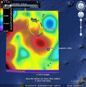
The presence of the eddy to our south correlates very closely with how the currents recorded by silbo changed as he moved from the smaller warm eddy to the larger one we are on the cusp of at the moment.  This large one is the source of the south east flow we are now encountering.

Above is an image created by Antonio showing the salinity showing that the eddy is so intense, that the effect on salinity can be seen all of the way down to 900m.  This eddy will fuel our progress over the next week or so as we ride it to the south east on our way past the savage islands.

Below we see the Hycom, NCOM and Nlom data sets for today showing a different perspective as the flows are generally in the south west direction:

Hycom Density

Hycom Salinity

Hycom SSH

Hycom Temp


NCOM/NLOM SSH and Currents


Now that we have made enough progress east, we are now in the domain to use a new website, MarineMet.  This website will provide useful data not only for Silbo’s continued progress as long as we remain within it’s limits, but it will also be useful for 29’s mission in the up coming months.

And finally, The Challenger Mission has a new web page with tons of history, background information and interactive images for everyone to see.  This new web page can be found here: http://challenger.marine.rutgers.edu/

For now, Force Wind Sea & Honor

Nilsen, Antonio and Oliver


Fighting to make the appointment

After we ran out of time attempting to sample the eddy to the north west of Madeira, Silbo now is fighting his best to sail back down to where our team plans to be tomorrow.  Carlos and a team from PLOCAN will leave port from the southern side of Madeira tomorrow at 10am local (5am est).  From there they plan on sailing west ~60 km to deploy drifters.  When planning this trip, we had hoped to have the drifters deployed around Silbo to get a nice data from multiple sources and to get a nice view of our brave little droid to see if there is any biological growth on his exterior.

HYCOM Sea Surface Height

Unfortunately, we have run into a strong head current as we are trapped on the east side of a large cold eddy, which combined with the presence of the Island is producing an incredibly strong northward flux in the area.  We will be keeping a close eye on silbos position as he surfaces. after each single dive to give us a new position.  We are hoping to cut our way through this strong head current to try and make it to a reasonable distance to still pull off a rendezvous.  We are being optimistic, but on the last segment, Silbo only covered 2km..

NCOM/NLOM Sea Surface Height and Currents

Tomorrow morning as our friends sail out for the recovery, we will try and catch their progress using the marinetraffic overlay which will easily prove its worth as we continue to the finish line where the shipping traffic is much busier than the peaceful west side of Madeira.

Marine Traffic Google Earth Overlay

We will keep everyone updated tomorrow with what excitement lies ahead.

Force Wind Sea & Honor to all

Nilsen Antonio & Oliver


Eddy Hunting!

Hey All,

Sorry for the gap in coverage on Silbo’s mission.  Our brave little droid is continuing to wait patiently in the area of Madeira as our team prepares to inspect and deploy a buoy at the end of this week.

Last week, Silbo went into his station keep agenda as he bounced back and forth between two way points for a few days as we killed some time.  Our team had spent quite a bit of time making calculating how long it would take for Silbo to arrive near Madeira and so we panned accordingly to get our team out there.  However, Silbo set a number of speed records for his mission as we saw some of the most favorable currents we have encountered since deployment back off of Iceland and we arrived quite a bit early.

For now, we have sent Silbo to fly to the North west of Madeira to sample a cold eddy before we swing back down towards Madeira for the rendezvous.

Nilsen & Antonio

Commence Operation Station Keep

Hey All,

So after brainstorming a number of ideas on what to have silbo do to kill time while our team from PLOCAN makes it out to Madeira for the rendezvous, Silbo has now begun operation station keep. Silbo is now only about 100km from Madeira, 8 days before our team will be able to arrive on scene.

Figure 1. Silbo now less than 100km from Madeira

Currently we are crossing the northern side of the warm eddy planet of the series that we have been surfing for the past two weeks.

Although the hycom layers show a northward flow, myocean sub surface currents all show a general flow right towards the island.

Figure 2. Hycom Density

Figure 3. Hycom SalinityFigure

Figure 4. Hycom Sea Surface Height

Figure 5. Hycom Sea Surface Temperature

Figure 6. Myocean Currents at depth

Figure 7. Ncom Nlom Currents and Sea Surface Height

The geostrophic currents in the above image of the ncom currents overlayed on nlom sea surface height agree with the flow shown at depth from myocean showing the current moving towards Madeira.  This flow again would be ideal if it wasn’t for the time frame we decided on before Silbo turned on the jets and set speed records as he made amazing progress over the past week and a half.

So to kill some time as our team makes their final preparation we are instating a station keep game plan.  This consists of setting two way points close together  (in this case 1823.8500W 3245.0050N and 1824.0000W 3245.0000N).  Silbo will then bounce back and forth between these two way points over the next couple days until our friends at PLOCAN are ready for us to move the way point back to the meeting point.

In deciding where we would station keep, we had to keep a few things in mind.  We needed to stay far enough away from the island to avoid shipping lanes, unfavorable bathymetry, and the effects of the tides.

Figure 8. Shipping traffic for this evening

Figure 9. Bathymetry around Madeira

We chose to try and keep Silbo west of 18˚ W to keep our heroic little droid out of the bad scenarios listed above.  Luckily the ships are pretty quiet tonight, however we will keep a keen eye on both the marine traffic overlays and the localizada ship traffic.

Finally, we are keeping an eye on the battery consumption to make sure we are not running low.  Currently it looks that we are still in the clear as our plots indicated we should be fine battery wise through to June.

Figure 10. Estimated Battery Consumption

We will update again soon on Silbo’s progress with the station keeping.


Nilsen Strandskov, Antonio Ramos, Oliver Ho.


New HD Road Maps

Finally!!! After 6 (nonconsecutive) months at sea, Silbo has finally reached the western boarder of the spanish ROM data!  This means we now have access to forecasts of up to 72-96 hrs in the future of ocean conditions with resolution up to 2 km^2

Figure 1. Myocean/IBI ROM Surface Salinity

Figure 2. Myocean/IBI ROM Salinity 220m

Figure 3. Myocean/IBI ROM Salinity 318m

Figure 4. Myocean/IBI ROM Salinity 643m

Figure 5. Myocean/IBI ROM Salinity 760m

Figure 6. Myocean/IBI ROM Salinity 1060m

Figure 7. Myocean/IBI ROM Surface Eastward Current Components

Figure 8. Myocean/IBI ROM Eastern Currents Coomponents 220m

Figure 9. Myocean/IBI ROM Eastern Currents Coomponents 760m

Figure 10. Myocean/IBI ROM Eastern Currents Coomponents 900m

Figure 11. Myocean/IBI ROM Eastern Currents Components 1060m

Figure 12. Myocean/IBI ROM Sea Surface Height

This data will prove to be very useful over the next month as Silbo makes his way to the Canaries and for future missions.  We all look forward to utilizing the 96 hour forecast as it will easily revolutionize how we pilot gliders from a reaction based system to an attack system where we can see what will happen up to 4 days ahead of time and use that to make piloting decisions.

Nilsen Strandskov & Antonio Ramos

Silbo Data analysis

Hey All,

So over this past week, I have been working on plotting up some data from Silbo’s mission so far and then also spent a little bit of time comparing his data to a near by Argo drifter.

Figure 1. 3d temperature plot of Silbo's track from Iceland to the Azores

Figure 2. 3d Salinity plot of Silbo's track from Iceland to the Azores

In figures 1 and 2, we can see how much the water conditions have changed from being almost uniform in temperature and salinity from surface to 1000m depth to being strongly stratified near the shores of the Azores.

Next I plotted more recent data, comparing Silbo’s temperature and salinity to what was recorded by a near by argo drifter, coriolis 6900511.

Figure 3. Temperature and Salinity profiles from Argo unit Coriolis 6900511

Figure 4. Temperature as recorded by Silbo

Figure 5. Salinity as recorded by Silbo

Although the Argo drifter went down another 1000m past what Silbo is capable of, the data shows a very nice correlation showing nearly the same shapes and depths for the thermocline and picnocline.

Nilsen


The pre passover easter update

Hey all,

So Silbo is still barreling on his way towards Madeira as the currents continue to unfortunately be favorable.  With the way the currents have been moving, it seems we may need to take some sort of evasive maneuver to prevent ourselves from getting too close to the island where we will find unpleasant bathymetry and some pretty heavy ship traffic.  The most likely scenario would be to station keep for a while (fly between two close waypoints) until the team with the drifter can get out there to inspect silbo and deploy the drifter.

Figure 1. Hycom Density

In the image above of density along with the images below from the hycom model, we can see that Silbo continues to ride down hill along the mesoscale as he heads towards his waypoint.  According to the models, it looks like if we were to go north a bit and fly with our nose into the cold eddy, we could slow ourselves down.  This could solve our problem of hitting speeds up to .45m/s

Figure 2. Hycom Salinity

Figure 3. Hycom Sea Surface Height

Figure 4. Hycom Temperature

Figure 5. Myocean Surface Conditions

Now looking at the myocean data to see what is going on throughout the water column, the salinity really portrays the best idea of what Silbo is dealing with subsurface.

Figure 6. Myocean Salinity at depth

Figure 7. Myocean Currents at Depth

Figure 8. Myocean Eastern Zonal Component currents at depth


It seems that deep salted cold fluxes of Mediterranean water have increased flow into the atlantic over the past couple months.

During the winter, the convective cell NW mediterranean is really intense (transmitting heat to the french, spaniard, italian coasts thus preventing its freezing.  This cold salted water sunk and streamed along the eastern coast of spain, flowing south and then left the mediterranean through the straight of gibraltar and sank down to 600 m.  The effects of the out reach of this salted mediterranean layer can be seen in the images showing salinity at 600, 800 and 1000m.

If you look at the salinity for the upper ocean, it is pretty uniform from the surface to 400m. However if you go deeper, Med water appears around silbo at 600 m, and have an affect until his deepest diving depth 1000 m.

Looking ahead, there are some salt driven eddies around him coming from the NE.  This most likely is the explanation of how different the current fields are between the surface-500m and 500m-1000m.

But the Mediterranean will not continue to be a huge driving factor much longer.  There is some cold but fresher water reaching up from the south that keeps the mediterranean waters north of Madeira

Force Wind Sea and Honor

Nilsen Strandskov, Antonio Ramos, & Oliver Ho

Race Against the Clock

But not in the typical sense…

Today Lauren Cooney of TWR gave us an update on the distances/speeds required to reach Madeira within the window of our friends from PLOCAN arriving there to deploy the drifters and provide an optical inspection.

Fig 1. Estimation plots of Arrival in Madeira and the Canary Islands

Shown in the above plots, we must keep an average speed of less than .23 m/s in order to not over shoot the proposed window and miss the rendezvous at Madeira.

Unfortunately, it looks like the surface currents are well against our favor at the moment..

Fig 2. NCOM Currents overlayed with NLOM Sea Surface Height

Fig 3. Hycom Density with geostrophic currents

Fig 4. Hycom Salinity with geostrophic currents

Fig 5. Hycom Sea Surface Height with geostrophic currents

Fig 6. Sea Surface Temperature with geostrophic currents

Fig 6. Hycom Sea Surface Temperature with geostrophic currents

Seen above in the images from hycom and nlom/ncom models, the currents at the surface are in a pretty steady flow to the south east in the direction of Madeira.  However if you look at the post from yesterday showing currents at depth, we see that sub surface the currents change direction resulting in the north eastern flow shown by silbo.  This is also possibly due to a warm core eddy that appears in sea surface height in Figure 2 (ncom/nlom) and Figure 5 (hycom).

Fig 7. MODIS satellite imagery of Chlorophyll Concentration

Fig 8. MODIS Satellite imagery of Sea Surface Temperature

The above images are from the modis satellites showing sst and chlorophyll concentrations for the area.  Chlorophyll showing a pretty large bloom up on the northern shores of Spain but relatively low activity in the vicinity of Silbo.  Meanwhile the sst shows the gradual cooling as we move away from the equator.

Fig 9. Silbo's Track on the first leg of the Challenger Mission

Finally, I just wanted to take a step back and admire how much distance Silbo has covered since last June as we are now less than 450 km to our destination on the shores of the Canaries.

Nilsen Strandskov & Antonio Ramos


Glider X-ing

Hey All,

Silbo continues the never ending story of the challenger mission as he maintains his course on the way to the western side of Madeira.

Fig 1. Silbo now 330 km from the shores of Madeira

Conditions all seem to be alright for our little droid as he continues making smooth dives to 1000m with no evident sign of biological interference, calm weather, and a path clear of any shipping vessels.

Marine conditions from our three data sets, hycom, myocean, and ncom/nlom all continue to show the strong current flowing south from our location, which we are seeing push Silbo slightly to the south.  However, we have turned on the current correction feature on this afternoon so Silbo will show signs that he is fighting the current to try and stay on a straight path to the current way point just to the south of Madeira.  Below is the imagery from our ocean models:

Fig 2. HYCOM Density for April 1st

Fig 3. HYCOM Salinity for April 1st

Fig 4. HYCOM Sea Surface Height for April 1st

Fig 5. HYCOM Temperature for April 1st

In the HYCOM images above (Fig 2-5), we can see how strongly the geostrophic flow of the ocean dictates the salinity, temperature and density of the surface waters as we can see evidence of the eddies in all four images.

Fig 6. Myocean Surface Conditions (temperature, salinity, eastern component currents, currents)

Fig 7. Myocean Sea Surface Height

Fig 8. Myocean temperature at depth

Fig 9. Myocean Salinity at depth

Myocean Eastward componenet currents

Fig 10. Myocean Eastward componenet currents at depth

Fig 11. Myocean Currents at depth

In the above images (Fig 6-11),  we see the surface conditions and that of which is at 200m, 600m, 800m, and 1000m form the MyOCEAN models of temperature, height, salinity, currents, and the overall eastward flow of the water.  These all continue to show a similar story to the hycom models of showing the eddy filled progeny of the tail end portion of the Gulf Stream.

Fig 12. NCOM Current Model and NLOM Sea Surface Height

Finally the ncom/nlom model of the land scape also shows the same as the above figures of the whereabouts of the eddies and similar movements of the currents.

Overall, we will wait and see how Silbo now flies these currents with the addition of current correction on as we continue on our way towards Madeira, remembering in the back of our minds that we are aiming to be there around the 17th- 20th.

Nilsen & Antonio

The Planet with the Dragon Tatoo

Hey All,

So there has been quite a lot of activity over the past couple days as we made a few crucial decisions for piloting Silbo.

First off, we have made a few way point changes ranging from east to south east as we are making our way through the eddy solar system we have been flying for the past few weeks.  We have also changed our flight parameters to flying at 300cc instead of 400.  This is to save power as we are no longer fighting strong head currents (which was the causation towards the beginning of the mission to make the decision to move it up to 400cc).  Also in an attempt to save battery, we are continuing to only turn on the ctd for 1 down cast for every two yo dive while doing one dive every two weeks to validate the data collected.

Temperature recorded by Silbo on March 28

Salinity recorded by Silbo on March 28

Density derived by Silbo's data from March 28

As seen in the three figures above, the down cast (blue) and up cast (red) and relatively along the same trend showing that the ctd sensor is still functioning well.

Taking these measures to conserve energy is also proving to be working very well. Below there are a couple figures showing energy consumption, estimated end date for the life of the batteries, and estimated distance that can be covered off of how much energy we have left.

Top: Amps/hr consumed so far Bottom: Estimated end date

Flight Estimation Plots for Silbo

Based on the above plots, Silbo should have enough battery to last until mid June and can cover about 2,500km,  well over the ~750 km track that Silbo will follow to get to the Canary Islands via sailing by the island of Madeira.   The remainder of the trip is estimated to be about another month and half, Madeira being about 3 weeks away.  Leaving Funchal’s harbor, Carlos and a team from PLOCAN plan on running an inspection to make sure there is nothing growing on the exterior of Silbo and will simultaneously deploy drifters in the water.  This will all happen about 50 km west of the island.

In order to most strategically fly silbo  to 50 km from madeira, it would be necessary to keep flying east for a while to make sure we can reach the rendezvous point without having to try and fly back to the north against the southern flow that goes from Madeira to the Canaries.  But once we get past the inspection, it should be relatively smooth sailing as we ride the tail end of the Canary current to our final destination.

To get better estimations of the time for the remainder of the mission, Daniel Hernández, Josep Isern, Enrique Fernández and the rest of the team from ROC-SIANI group at ULPGC used their simulation to see how long it will take Silbo to get to the Canaries.

Pinzon path planning estimation using myocean


Pinzon path planning simulation using hycom

Currents comparison recorded by Silbo (g) hycom (b) myocean (m)

These estimations show we should be in the vicinity of Madeira within the next two weeks or so.  However we may need to delay a bit as we need a little more time for our team to arrive.  However it seems Silbo has plenty of battery power to bide a little time.

Based off of speeds Silbo has reached thus far on the mission, if Silbo maintains a speed of .35 m/s, we are looking at an arrival at Madeira by april 9-13, .3m/s would give us a date of april 11-15, or .25 m/s would land us at april 13-17.

To make sure we find the most ideal path, we have been keeping a keen eye on our various ocean models, both on the surface and at depth.

myocean surface conditions for temperature, salinity, currents and sea surface height

myocean temperatures at depth

myocean temperatures at depth

myocean salinity at depth

myocean currents at depth

ncom currents and nlom sea surface height

hycom density and currents

hycom salinity

hycom sea surface height

hycom temperature

The ocean models shown above (myocean, ncom/nlom, hycom) all show the general trend in the currents we have seen agreeing with the currents recorded by silbo.  As for now we will continue to follow the way point as we continue to make progress to the east.

Finally, I would just like to point out some beautiful imagery from the modis satellite imagery of the north atlantic of temperature and chlorophyll (where I got the title from).

modis sea surface temperature

modis chlorophyll imagery

check back soon for more updates on Silbo’s journey!

as always, Force, Wind, Sea & Honor

Nilsen Strandskov, Antonio Ramos, Ben Allsup, Lauren Cooney & Oliver Ho

« Older posts Newer posts »