Category: ru29 (Page 5 of 22)

Radio Silence

After we last heard from RU29 Friday morning, the glider gave us a scare by not calling in until we were well into Saturday.
In total the glider was silent for about 23 hours before it called in to Teledyne’s dock server. After discovering this, Dave was able to grab a hold of it and get it back under control.

RU29_20160109_waypoint

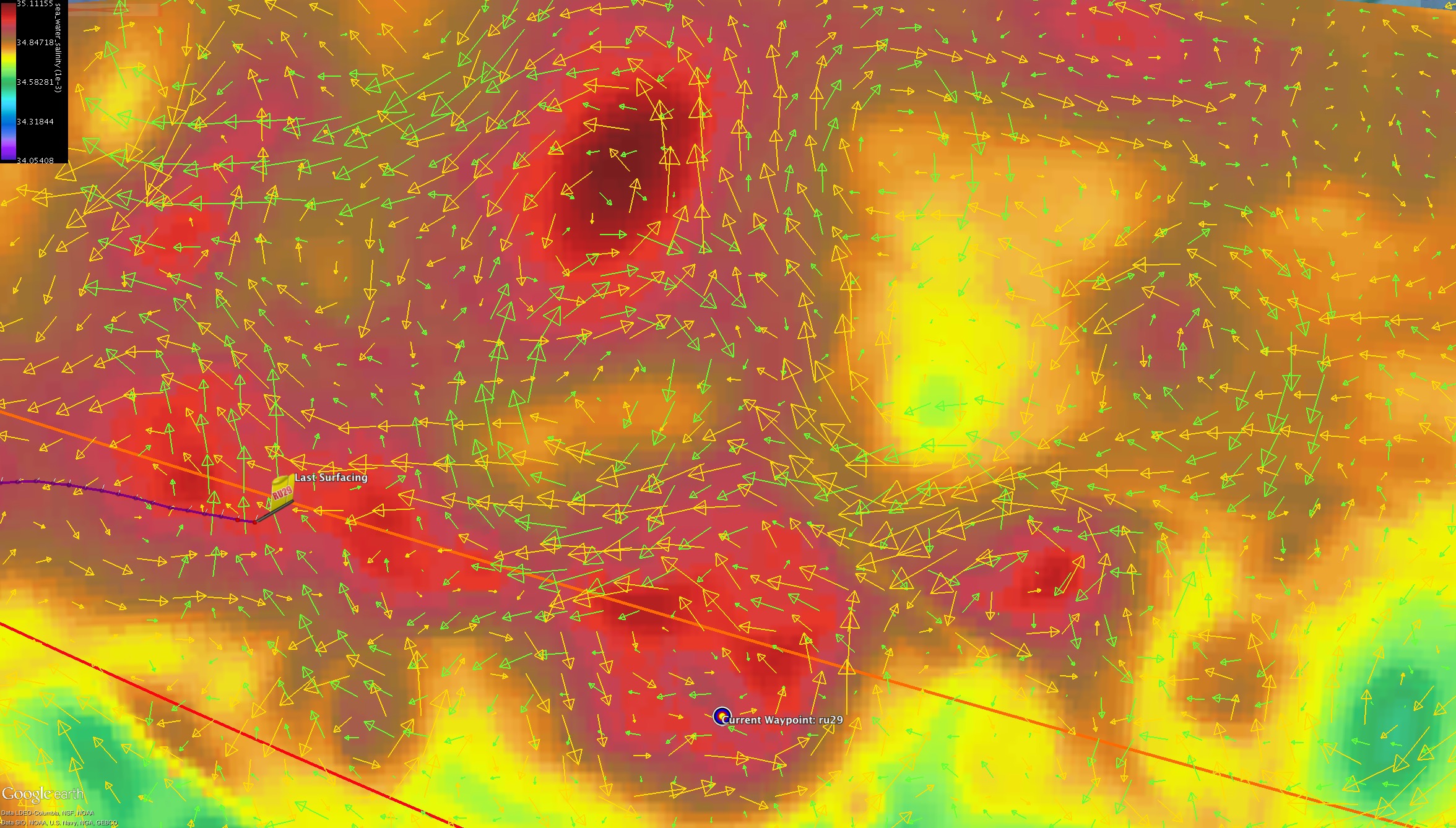
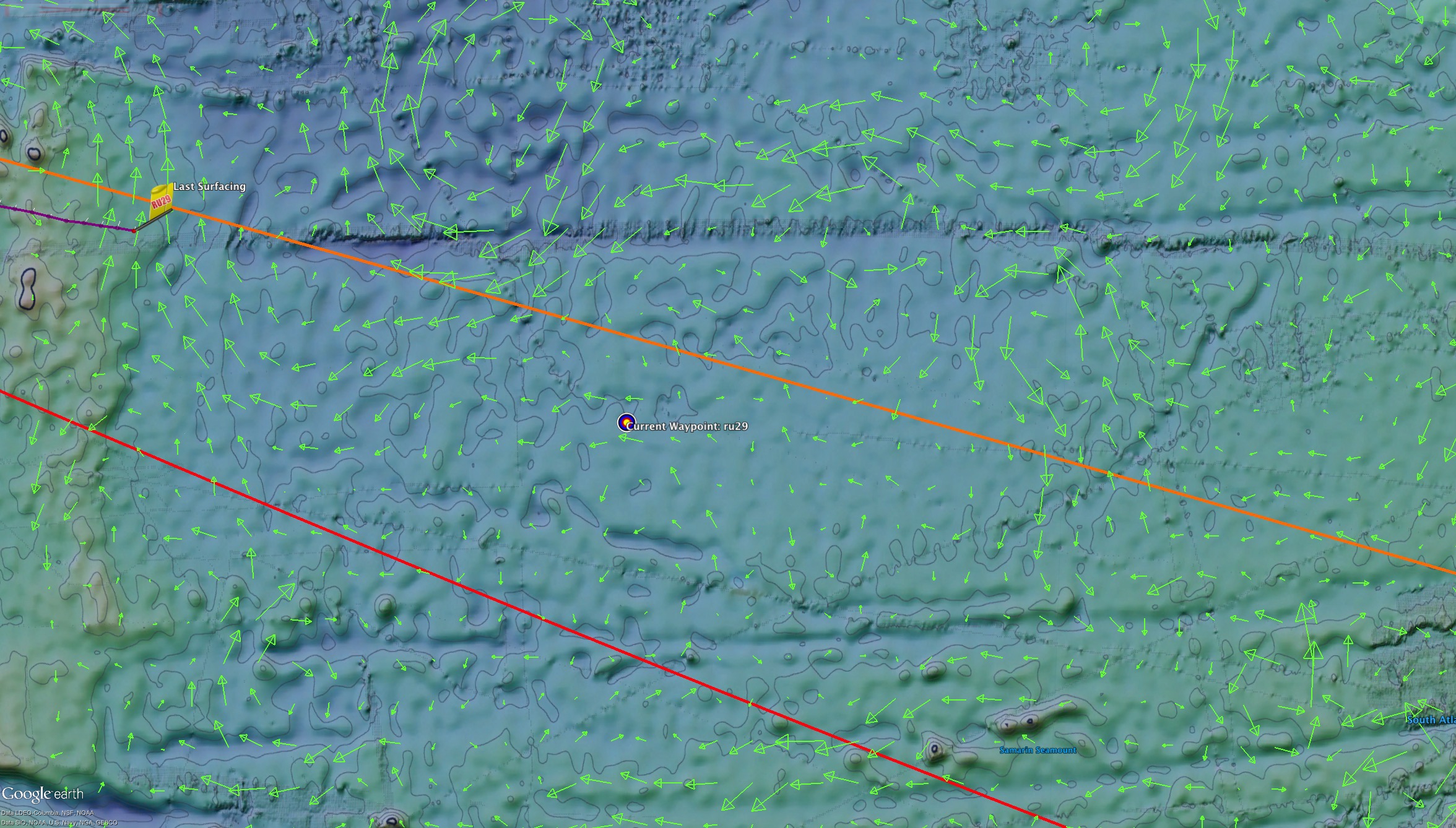
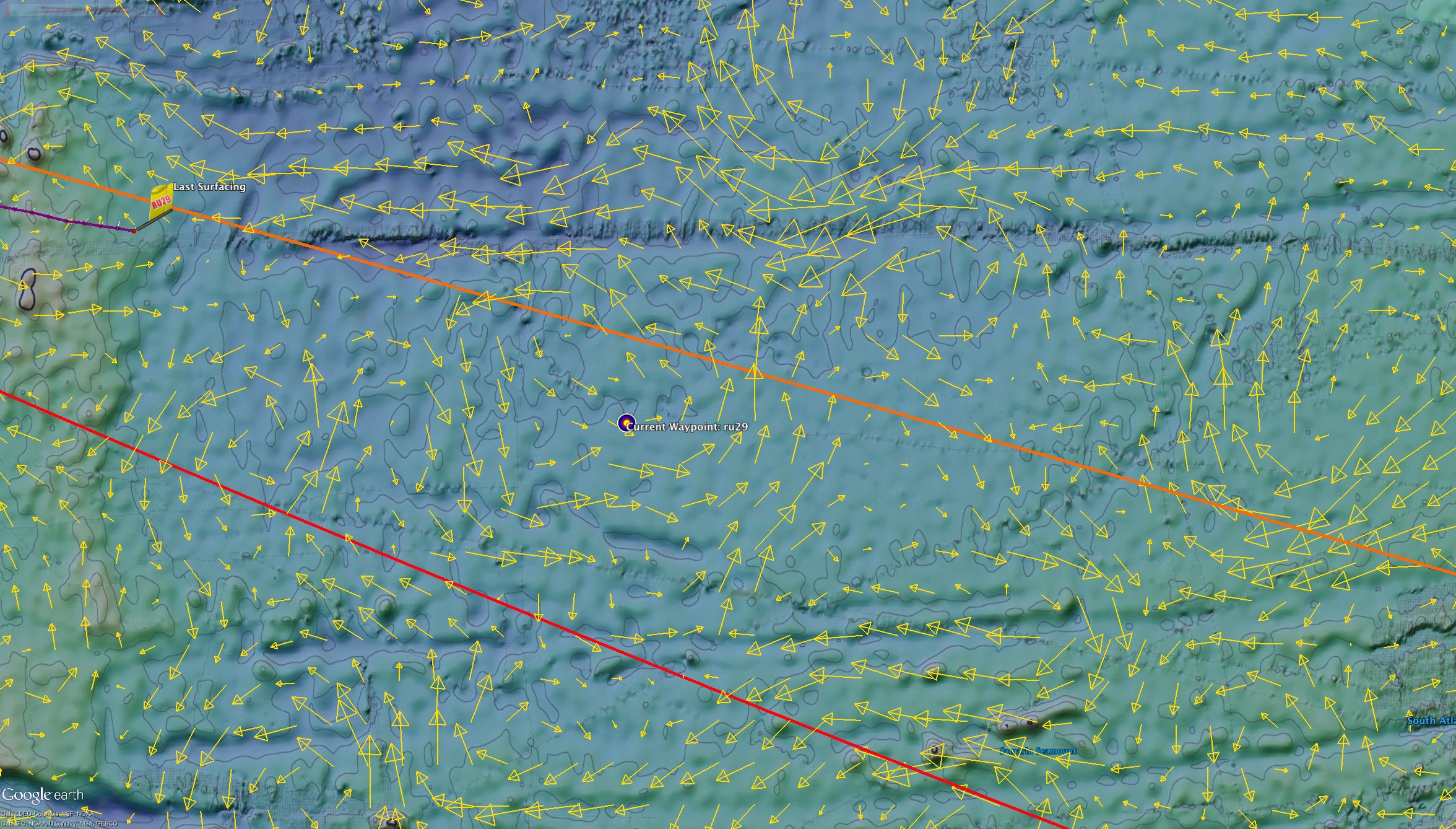
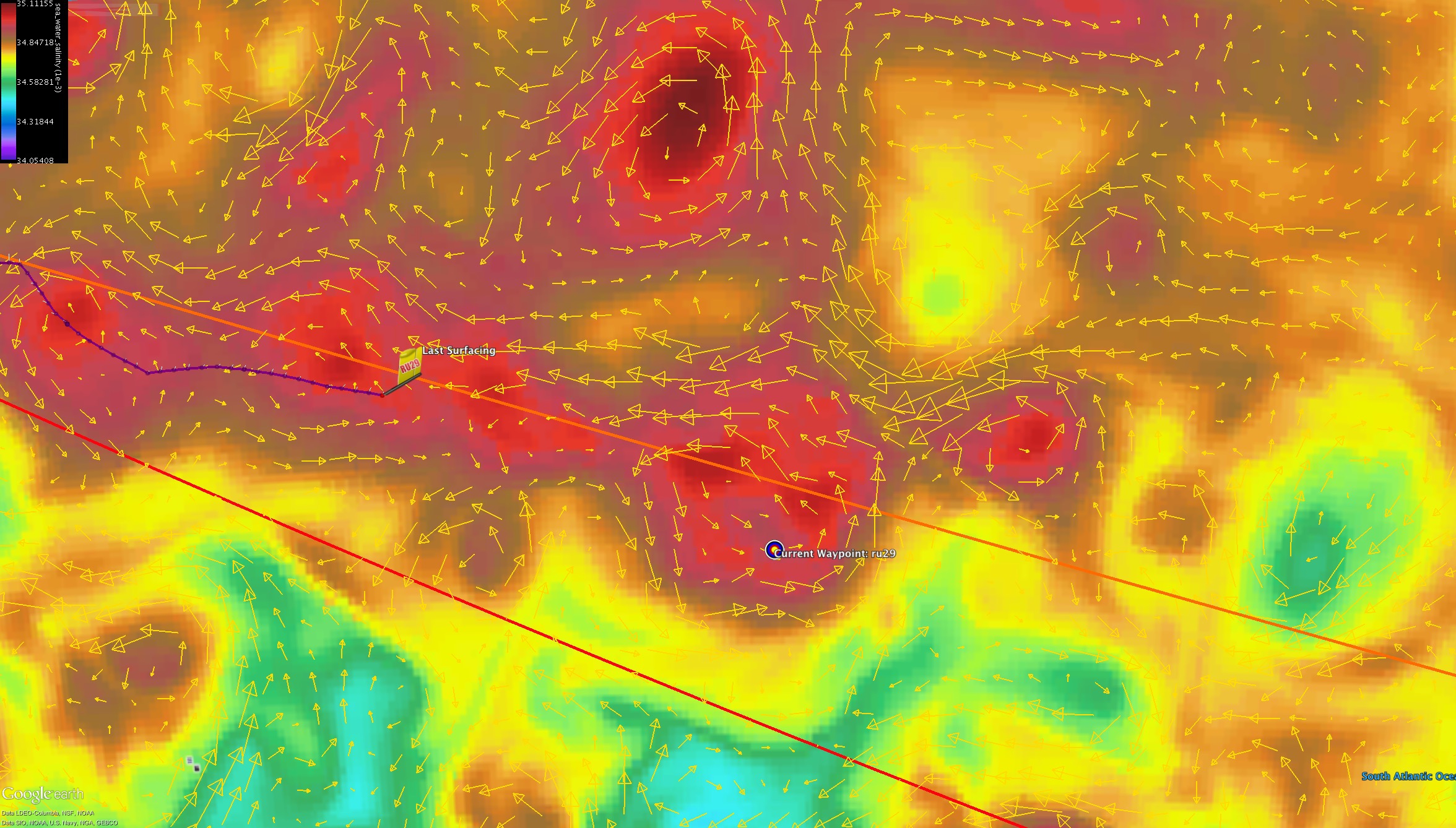
Now that Challenger is back, a new way point as 34˚ 30’S, 6˚ 00 E was issued to try and get the glider flying at a good angle as we enter the next eddy.  Once the entrance is made, the way point will be shifted as we do our best to ride the strong currents that lie ahead instead of dissecting the eddy through the middle.  Once we make our way through this eddy, we will be just 3 more major eddies away from a recovery approach in South Africa

RU29_20160110_1400km


RU29 in now less than 1400 km from Cape Town  as the crow flies; assuming the crow follows the great circle route.
The purple line in the image above is the likely path Challenger will take as we navigate the remaining eddy field dipicted by the Copernicus currents.  This predicted path is roughly 150 km longer at ~1550km between 29s last position and our goal.

Diagnostics wise, power use is still holding steady at 2.3 AH/day which will allow for about 146 more days on the battery clock.  Current speed made good towards Cape Town is also running about 28 km/day which means if all continues to go well we can reach our goal in about 60 more days.  Finally Steering rms error is still about 15 degrees.

Force Wind Sea & Honor

1500km to Cape Town

Now 1500km from Cape Town and 1100 km from the closest point of South Africa’s EEZ, Challenger continues to push onwards toward her goal of crossing the South Atlantic from East to West.

RU29_20160107_1486km

Over the past few days Challenger has been pushed further to the north than we wanted, but was still left in a position where we can follow the path outlined last time by the purple line in the image above.  In the coming weeks, we will aim to surf the southern side of the two eddies as we work East-Northeast across the stream coming around the edge of South Africa.

In order to make the entry point for the leading eddy, we will change the way point to 35˚S, 5˚E

RU29_20160107_waypoint

Power use is remarkably steady at 2.3 Amp Hours/day.  The recent peak at 2.8 AH/day was when we turned on the altimeter to get across the final group of seamounts.

ru29_Power_20160107
If our battery power calculations are correct, at this use rate, we have 150 days of battery power left on board. 1500 km to go with 150 days of power on board means we need to beat 10 km/day made good to make it. So far throughout the mission we have only come near that minimum once at 11km while presently we are closer to 30 km/day

ru29_Speed

And this speed is something we need to try and keep steady for as long as possible:

ru29_heading_StatisticalTimeSeries_20160107
Currently, our average heading error (red) is small – only a degree or so, however  the standard deviation of the heading error (blue) is trending upwards.  This heading error is a sign of biofouling and most likely the barnacles which have plagued the long duration glider missions over the years.
As the critters grow, the vertical speeds slow down, less water flow over the fin, resulting in more heading errors.

Hopefully we’ll be able to maintain Challenger’s speed as we work our way from eddy to eddy and get to South Africa as soon as we can

Force Wind Sea & Honor

Winter Holiday Wrap-up

Through the winter holiday, Challenger continued to make good progress while not only breaking speed records for the mission, but crossed back over to the Eastern hemisphere for the first time since early 2013.

As Challenger continued her approach to the Prime Meridian, we saw a nice correlation between the currents across the board as the depth average currents from the glider matched the eddy in both copernicus and RTOFS.

RU29_20151226_copernicus

RU29_20151226_rtofs

While making her way across the southern edge of the eddy, Challenger broke her mission speed record, breaking 37 km/day.

ru29_Speed_dec26

Then as 29 finally crossed the Prime Meridian, the glider began to feel the push of the eastern side of the warm core eddy.  In order to avoid the seamount to the east, we let the glider follow the flow of the eddy and rode it to the north.  The seamounts although labeled as only reaching to 750m from the surface while Challenger  is diving to 550m, the depths are not always accurate and so we like to keep a level of caution when flying by one.  The altimeter was also turned on as a secondary temporary precaution.

RU29_20151228_CrossPrimeMeridian

So now the challenge is the biofouling.  We are not flying as deep to help save the pump and reduce the power draw, but we see the slow deterioration in steering and vertical velocity. So we are still in a race. We have to get to Cape Town before the biofouling slows our progress to the point where we loose our steering.

Now just 1750 km from where she was deployed in Jan 2013, we are looking ahead at the stream of eddies we will navigate in the coming months as we get Challenger back to South Africa and complete the flights for the South Atlantic.

RU29_20151228_1750km

Force Wind Sea & Honor

April or Bust

After pursuing the waypoint set at the end of last week through the weekend, Challenger has continued to see a consistent push to the north by the current.  Late yesterday to try and better counter this force, the waypoint was shifter further east and slightly more to the south to try and have 29 hit the edge of the eddy at a nice angle to ride it around to the south when the glider reaches that point a little later this week.


challenger_1221rtofs

In the RTOFS forecast, the model is showing the Challenger has nearly reached the edge of the elongated eddy and says that the current should now be flowing north to south-south east representing the south west sector of the warm eddy.  However, the currents as they are reported by the glider seem to be going in the opposite direction flowing to the north with a little bit to the west.

challenger_1221copernicus

In Copernicus, the model matches up much closer to the gliders report, showing a weak counter current to the rotation of the eddy whose presence is still a little ways away.

ru29_VerticalVelFouling

Over the past few days, Dave and Antonio have further discussed the change in vertical velocities seen by the glider over the past few months.  Starting in October, the glider had seen more time at the surface due to the trouble shooting of the pump which needed to be done.  This increased surface time then allows for a greater chance of  successful settlement of larval stage organisms such as barnacles on the hulls.

If we are seeing the effects of biological growth on the gliders, combined with issues still being dealt with with the pump, it will build up a case to increase pitch angles (faster and less oddities for pump) and fly a little deeper, perhaps longer too in order to  slow down the growth.  Either way, we believe if we can complete the journey by April the glider should be in good shape

Force wind sea & honor

Approaching the Eddy

challengerdec18

Challenger, now under 2000 km from Cape Town is finally on the cusp of the eddy we have been positioning the glider for over the previous weeks.

challengerdec18rtofs

In RTOFS, Challenger is right on the west-southwest edge of the more elongated eddy, however what the model shows of the current flowing to the south-southeast is nearly opposite to what the glider is reporting of to the north.

challengerdec18copernicus

Similarly in Copernicus, although the eddy is more defined and compact a couple hundred km to the east, the model is again showing a southward flowing current contradictory to what the glider is reporting.

Over the next couple days, as 29 enters the eddy ahead the way point will be moved to the south east as we ride the southern edge of the eddy across the Prime Meridian.

Force Wind Sea & Honor

<2000km to South Africa

Now less than 2000km from the shores of South Africa, Challenger is continuing to inch her way across the map towards a more immediate goal: the Prime Meridian.

Last Thursday afternoon we pushed the waypoint further east in order for 29 to fly more perpendicular to the weak northward flow she had encountered.  Through the weekend however, this current has picked up a bit (from .03m/s to .08m/s) and rotated to the north west, providing 29 with some more head on resistance.  This change in direction of the currents is something we can see a few hundred km ahead in copernicus, but in the immediate area it almost looks like the sum of the east-west component of the copernicus model combined with the north-south component of the RTOFS model

RU29_20151213_waypoint

Since the current is blowing more directly into Challenger’s nose, we moved the waypoint a little further north (to 35˚ S, 1˚ 30′ W) to try and fly a better angle against the current.

Over the weekend we also saw Challenger surface due to an abort.  After looking into what happened, it was discovered that during the previous surfacing Challenger did not maintain the connection long enough to reset her timer, so then when she dove again and continued to fly she eventually hit her time limit and came to the surface with the abort for no-comms.  Since this happened on Saturday afternoon she has continued to fly without any issues.

Looking ahead, over the next week 29 will continue to make her way towards the warm core eddy sitting at the Prime Meridian.  From there we will likely aim for the southern edge of the two weaker warm core eddies as we ride them to the north east before making our final approach towards Cape Town.

ru29_1214

One last note, looking at Dave’s vertical velocity plots, we are noticing a downward trend from the past few months showing that the glider has lost about 10% of its original speed, largely starting since October.  This could potentially be due to biofouling especially since we have reduced our dive depth to 500m for the past 5 weeks.  One suggestion so far has been to weigh the options of if we were to dive deeper again, the pump slipping vs the distance lost to being slowed down by barnacles.  But for now this is just speculation and will be discussed further in the future.

ru29_VerticalVelFouling

Force Wind Sea & Honor

New Way Point: 35˚23’S 1˚30’W

Over the past 4 days, Challenger has been countering the northward current by flying towards perpendicular to the east. Since then, the currents let up a bit allowing Challenger to fly more quickly through the water, shown but the increase of 20 to 23 on the figure below:

ru29_Speed

However, now the current although still relatively weak, is rotating back to our nose, so we have pushed the waypoint a little further away to 35˚23’S, 1˚30’W.  This will keep the glider flying along the white line shown below which is the direct path from Challengers latest location to the shores of cape town.  This path also does a nice job of lining the glider up to fly smoothly through the eddy that is resting on the prime meridian while steering us clear of any unfavorable bathymetry.

RU29_20151210_waypoint

Force Wind Sea & Honor

Pushing towards the Prime Meridian

Through the weekend Challenger continued to fly towards the waypoint assigned towards the end of the week at 35˚30S, 4˚W.  With the current correction off, this allowed the glider to ride the northward flux along the arcing red path proposed in the previous post.

RU29_20151207_RTOFS

There is a counter clockwise eddy in both RTOFS (green) and copernicus (yellow)
in nearly the same locations.  In the figure above, the oval RTOFS eddy is outlined in green, and the perfectly round copernicus eddy is outlined in yellow.

RU29_20151207_Copernicus
In the two figures above, the straight green line is the line straight to Cape Town.
We want to keep RU29 between the straight red line to the south and the straight orange line to the north, while keeping as close to the green line as possible.

The waypoint decision we made last week revolved around how to approach the eddy near the Prime Meridian prominent in both models.  We had 2 options, the northern curved route (red) or the southern curved route (orange). The glider currents were persistently pushing us north and the currents along the northern track were consistent through both models, so we made the decision to go with this flow, and pursue a track along the northern red line.

ru29_20151207
For the foreseeable future, the bathymetry looks unobtrusive so as Challenger continues across the Prime Meridian (for the third crossing of the Challenger mission) and on towards Cape Town, we can rest easily when it comes to dodging sea mounts.

And finally below we have a field of the locations of the Argo floats that lie ahead.  Through the remainder of the mission we will attempt at approaching at least a few of these sampling devices for comparison and quality control purposes.

RU29_20151207_2100km_argo

Force Wind Sea & Honor

Taking the high road

Challenger has now been at sea for over 160 days and flown 4,100km and is continue to push onwards towards her goal of the shores of Cape Town South Africa.

Yesterday the team put their heads together on whether to turn to the north or south to navigate through the currents that lie ahead.

RU29_20151102_RTOFS

Despite the RTOFS (in green above) and Copernicus (in yellow below) disagreeing about the northern flux currently affecting 29, both models agree that if we continue pursuing the latest waypoint, we will enter a pretty persistent head current.

RU29_20151202_WaypointChange

As seen in the figures above, the Copernicus shows a pretty promising route to the south that RTOFS shows as being more of a mess.

To the north however, both models show what seems to be a number of more defined eddies that have meshed together.  This is the option that the team ultimately decided upon using the red path shown in both figures.  Beginning today and following through the weekend, Challenger will start pursuing the new way point at 35˚30S, 4˚W to swing her way to the north and through the eddy field.

As for the troublesome pump, we are continuing to take a few precautions to reduce the slipping we have seen over the past couple of months.  The slipping we have seen is caused by the oil that dictates the buoyancy of the deep glider leaking within the pump section of the glider, resulting in the pump having to move multiple times over the course of a dive/climb in order to maintain it’s flight path.  In order to reduce the number of times the pump has to move (which increases the wear and tear on the pump), Dave has reduced the depth 29 dives to to 500m and has adjusted the pitch angle on the dives and climbs.  By adjusting the angle, we are then able to change how quickly the glider moves through the water column with the aim of reaching the inflection depth before the pump has a chance to slip.  The issue has been variable over the past few months, but the team has been hard at work diagnosing and testing the issue along the way to find the best way to fly under the circumstances.


Force Wind Sea & Honor

Riding the under current

Now over two months and roughly a quarter of the way into the mission, Challenger is continuing to make good time consistently reporting speeds of over 25km/day as she weaves her way through the stream of eddies across the South Atlantic.

In a previous post, we had mentioned one of these large eddies to our East as being an interesting test case to study as RTOFS interpreted the area as being a large cold core eddy while Copernicus showed the area being two warm core eddies rotating to the north and south of the region.  As we have approached this location and the forecast has evolved over the two weeks, the two models have come to a similar conclusion that there is a cold eddy solar system (cold eddy with a number of warm eddies surrounding it as seen below)

solarsystem


Looking at how the currents progress through this solar system, we unfortunately will have to take a southern route in order to keep our progress in the Eastward direction.

sept1rtofs

RTOFS Averaged Currents Sept 1 2015

Both models from our current location look to be agreeing to an extent as they are both showing the glider leaving the presence of a small warm eddy.


sept1coper

Copernicus Averaged Currents Sept 1 2015

From here, we plan to continue following the southern edge of this stream of eddies outlined by the  front in the salinity field (barrier between red and orange in the image below).  Over the next week or so we will shift the way point further to the south as we line 29 up to step to the south east along that path

500msept1sal

Copernicus Averaged Currents overlaid on top of the Salinity field for 500m depth Sept 1 2015

Finally, Dave recently noticed we have been getting oddities in the readings of the oil pump used to drive 29 and will be investigating the issue further.

Force Wind Sea & Honor

« Older posts Newer posts »